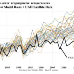
De pierievjoed littretjoer heeft een nieuw minimum bereikt:
De Telegraaf kopte op 17 februari:
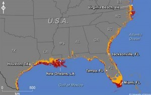
Stijging zeespiegel bedreigt 180 steden VS
WASHINGTON – Volgens onderzoekers krijgen 180 steden in de Verenigde Staten in 2100 te maken met overstromingen en erosie door een stijgende zeespiegel. Dat meldden ze woensdag in het tijdschrift Climate Change Letters.
Het blijkt gebaseerd op een persbericht van Reuters van 16 februari met een alarmistisch kaartje:
Rising seas threaten 180 U.S. cities by 2100: study
Reuters) – Rising seas spurred by climate change could threaten 180 U.S. coastal cities by 2100, a new study says, with Miami, New Orleans and Virginia Beach among those most severely affected.Previous studies have looked at where rising waters might go by the end of this century, assuming various levels of sea level rise, but this latest research focused on municipalities in the contiguous 48 states with population of 50,000 or more.
Cities along the southern Atlantic coast and the Gulf of Mexico will likely be hardest hit if global sea levels rise, as projected, by about 3 feet (1 meter) by 2100, researchers reported in the journal Climate Change Letters.
“Climate Change Letters”
Het tijdschrift Climate Change Letters was mij onbekend, maar wat googelen op de onderzoeker die in het persbericht wordt genoemd, Jeremy Weiss, wijst al snel naar de juiste referentie:
Weiss, J.L., J.T. Overpeck, and B. Strauss. 2011. Implications of Recent Sea Level Rise Science for Low-elevation Areas in Coastal Cities of the Conterminous U.S.A. Climatic Change DOI 10.1007/s10584-011-0024-x.
Climatic Change dus , en de oude bekende Overpeck is ook van de partij.
Reuters gaat verder:
The U.N. Intergovernmental Panel on Climate Change (IPCC) has estimated global average temperature will rise by 3.6 degrees F (2 degrees C) by 2100. However, Weiss and his colleagues put the warming at more like 8 degrees F (4.4 degrees C).
Tja dan wil de zeespiegel wel een meter stijgen, als je het IPCC te conservatief vindt. Hier is het abstract:
ABSTRACT
Recently published work estimates that global sea level rise (SLR) approaching or exceeding 1 m by 2100 is plausible, thus significantly updating projections by the Fourth Assessment of the Intergovernmental Panel on Climate Change. Furthermore, global greenhouse gas (GHG) emissions over the 21st century will not only influence SLR in the next ~90 years, but will also commit Earth to several meters of additional SLR over subsequent centuries. In this context of worsening prospects for substantial SLR, we apply a new geospatial dataset to calculate low-elevation areas in coastal cities of the conterminous U.S.A. potentially impacted by SLR in this and following centuries. In total, 20 municipalities with populations greater than 300,000 and 160 municipalities with populations between 50,000 and 300,000 have land area with elevations at or below 6 m and connectivity to the sea, as based on the 1 arc-second National Elevation Dataset. On average, approximately 9% of the area in these coastal municipalities lies at or below 1 m. This figure rises to 36% when considering area at or below 6 m. Areal percentages of municipalities with elevations at or below 1-6 m are greater than the national average along the Gulf and southern Atlantic coasts. In contrast to the national and international dimensions of and associated efforts to curb GHG emissions, our comparison of low-elevation areas in coastal cities of the conterminous U.S.A. clearly shows that SLR will potentially have very local, and disproportionate, impacts.
(vette tekst van mij)
Ahaaaa: ZES METER, oh waar hadden we dat getal al eerder gehoord?

Juist: Al Gore.
Weiss heeft dus hetzelfde tekenpakket als Al Gore gebruikt om een oud verhaal te herkauwen, maar met “nieuwe data” Maar ach die shuttle radar data is ook al zes jaar oud, en wordt uitgebreid in wikipedia gebruikt door kaartenmakers.

Iedereen kan schilderen.


Off-topic schilderijtje?
Das & Boom is weer terug van weggeweest, opnieuw opgericht dus, nadat ze tevreden was gaan slapen, na alle "successen". Ze gaan weer procederen, tegen nieuwe rijkswegen, tegen het kabinetsbeleid, tegen Bleker, vóór de Korenwolfjes!
Das & Boom hadden vanochtend politieke spreektijd bij TrosNieuwsShow. De man van Das & Boom (ik wil geen namen noemen) liep volledig leeg in boosheid tegen Bleeker, tegen Elsevier en tegen de "haat" van de anti-milieu-beweging (bloggers?). Het was een soort Ghaddafi-toespraak met hel en verdoemenis, een zeldzame woordendiarree.
Over de schofterige beleid van Bleeker, over het negatieve PBL-milieu-advies, over de Korenwolfjes, over de Europese milieuverplichtingen, over milieu-verdragen en milieuregelgeving, over "5 over 12" in Nederland, over dat Nederland een voorbeeld voor de wereld en de natuur moet zijn, en als dat niet lukt dat het voor zijn kleinkinderen er zeer zorgzaam uitzag. (die kennen we!)
Ook over de Klimaat & milieu-stokpaardjes van gevaar van "over-consumptisme" in de 3de wereld met mobieltjes, koelkasten en auto's. (Derde wereld mag onze welstand niet worden verboden, wat is dat nou voor inconsequent Links milieu-eco-egoïsme!)
De man van Das & Boom liep dus volledig leeg. Zo bijzonder dat ik er nu aandacht aan besteed! (u kunt het terugluisteren op http://www.radio1.nl/trosnieuwsshow)
Het was de Wageningse leugenfabriek, die werd opgevoerd en milieu & klimaat-alarmisme ten top, over de noodzaak (= slechts Groen & Links politiek wens en geen wet!)van een Ecologische Hoofdstructuur in Nederland zo snel mogelijk uit te voeren met belastinggelden en subsidies. "We zijn het rijkste land ter wereld. En als het in Nederland niet lukt, wat moet er dan van komen in de wereld?"
Per radio collecteerde Das & Boom voor de nieuwe rechtszaken door Das & Boom tegen het kabinetsbeleid! U kunt geld gaan overmaken aan Das & Boom voor rechtszaken tegen het kabinet!(extra reclame: http://www.dasenboom.nl/ !)
Wat niet bij Das & Boom opkwam was, te collecteren onder de politieke aanhangers voor de 700 miljoen € nodig voor de ecoducten om de Groen & Links gewenste Ecologische Hoofdstructuur in Nederland te kunnen realiseren. Die 700 miljoen € vallen nu weg omdat er bespaard wordt door het kabinet, omdat er politieke prioriteiten zijn gesteld, terecht dus ook op Groen & Linkse klimaat % Milieu hobby's.
Milieubeleid is nu in "besparingsmode" het beste regionaal politiek te organiseren, na jarenlange nationale en Europese milieu & klimaat dwingelandij. Dat wil Bleeker, dat is democratie, dat is politiek.
Op een bijna "heil-klimaat/milieu" radiotoespraak van Das & Boom tegen dit kabinetsbeleid (dat is nu eenmaal politiek/democratie), daar zitten we niet op te wachten in Nederland.
Journalistiek onderzoek verdwijnt steeds verder naar de achtergrond, en uit gemak neemt men vaak klakkeloos persberichten over. Voor het opzoeken van zulke persberichten kun je ook de website Churnalism.com gebruiken.
Op http://www.churnalism.com knip en plak je het (zogenaamde) nieuwsbericht en de site zoekt het herkauwde persbericht op bij diverse nieuwssites (engels).
De titel "Rising seas spurred by climate change could threaten 180 U.S. coastal cities by 2100" vindt via http://www.churnalism.com al zo'n 4 nieuws-sites die het bericht hebben overgenomen.
@leClimatique
Die 4 nieuws-sites die churnalism vindt, stammen uit 2010 en 2009, dat is ver voor de publicatie in climatic change. Die artikelen zijn dus niet gebaseerd op Weiss et al., 2011.
@ Turris
Ik vind je spammen, ondanks je goede bedoelling. Voor een off topic link dumps is er off topic link dump.
@leClimatique: re "churnalism" zie mijn bericht op deze site: februari 24th, 201120:38at (bruinegebakken bosuilen).
OK Hans, ik kende de off-top-c link niet, wellicht duidelijker in het hoofdmenu op te nemen!
Je mag mijn off-topic ergernis daar naar toe verplaatsen.
De auteur heeft waarschijnlijk nog nooit gehoord van het begrip "continental subsidence".
De oostkust van de VS en de Golf van Mexico zijn zogenaamde "passive continental margins". Op deze margins vinden geen tektonische activiteiten meer plaats. De oceanische korst bij een passieve margins koelt af en wordt daardoor zwaarder. Dit heeft tot gevolg dat de passieve randen van de continentale platen mee dalen.
Zeespiegel stijging is bijna altijd relatief omdat er vele factoren een rol spelen bij zeespiegel stijging en daling. Het is heel moeilijk om een globale zeespiegelstijging te identificeren.
@Hans, inderdaad churnalism vond inderdaad alleen wat overeenkomstige alarmistische termen. Daarentegen wordt het copy-paste gehalte wel duidelijk als je de titel in google zoekt. Vele honderden hebben het persbericht overgenomen, van Yahoo tot Huffingtonpost.
http://www.google.nl/search?q=Rising+seas+threate…
@Tinstaaf, inderdaad daar was het van. Ik had het deze week ergens gezien die site :-)
@hans: zie je wel. even verder kijken en je ziet hoe overbodig de moderne journalistiek is geworden